| Year | 2015 |
| Credits | Ben SimonsTech Lead Darren LeeSoftware Developer Dr Wei Liu, Data Science Research Leader, Advanced Analytics Institute, UTSDeveloper: HSDH Data Visualisation Map |
| 3D Stereo | No |
| Tags | google maps hsdh parallel coords |
2D HSDH / Google Earth / Parallel Coordinates
This project uses public data provided by the NSW government that describes the provision of services throughout the state. This information allows us to see the distribution of government contracts throughout the state.
The DAVM was deprecated in 2019.
Parallel Coordinates
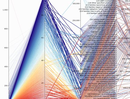
The information was provided to us in the form of a spreadsheet. We loaded the data into a parallel coordinates visualisation and linked this to a map of NSW. When a user made selections within the parallel coordinates graph, the corresponding local government areas were highlighted on the map.
Parallel coordinates is a powerful visualisation technique for comparing multiple variables in your data sets. You can learn more about this approach in our wiki.
Google Maps
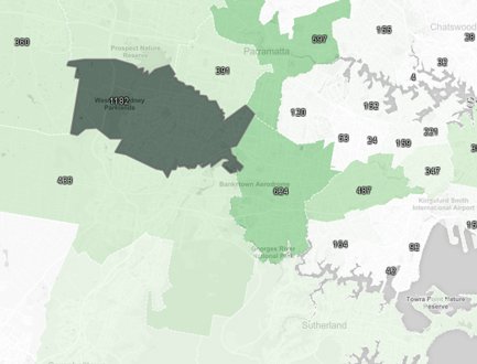
We used Google Earth to create a representation of the local government areas in NSW, so that as users make selections within the corresponding parallel coordinates graph, they were able to see the associated region highlighted within the map.
The map allows viewers to see where the selected government contracts are located and which government areas have received which type of contracts.
Google Earth
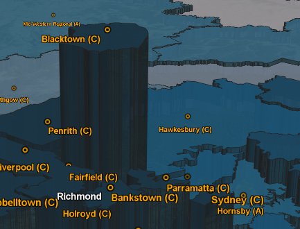
We also used Google Earth to represent the information in 3D, allowing users to fly through the data set interactively using a space navigator input device.